
FieldSight.
Research into satellite imagery, rainfall records and farm credit.
The idea
FieldSight will study whether satellite imagery, rainfall data and farmer delivery records can help lenders assess farm credit.
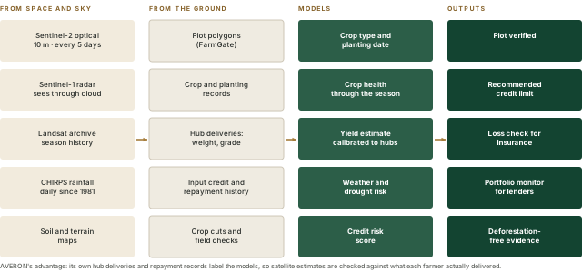
A World Bank study in Uganda found that satellite estimates captured about half of the variation in measured maize yields on pure-stand plots, but did worse on intercropped plots and needed calibration with ground data.46 The research would compare satellite estimates with crop measurements and delivery weights from registered farmers.

The data
| Data | What it tells us | Source |
|---|---|---|
| Sentinel-2 optical imagery | Crop presence, type and health through the season | European Union Copernicus; 10 m, every 5 days, free42 |
| Sentinel-1 radar and Landsat | Crop growth under rainy-season cloud; past seasons on the same plot | Free and analysis-ready through Digital Earth Africa43 |
| Daily rainfall | Rain on every plot since 1981: drought and flood history | CHIRPS, free44 |
| Plots, deliveries and repayment | Where each plot is, what it produced and what was repaid | AVERON farmer record and hub intake |
Proposed use in credit assessment
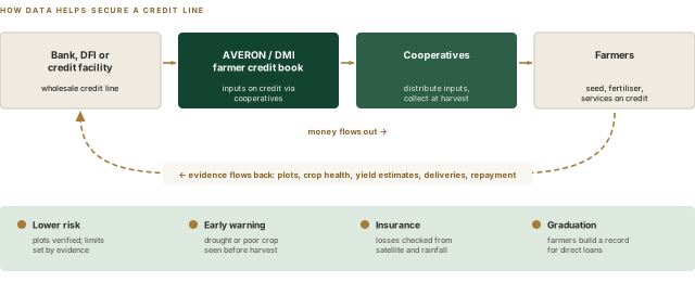
- Limits set by evidenceA verified plot, a growing crop and a delivery history justify a larger input-credit limit; a weak season shows early.
- A credit line lenders can seeBanks and development lenders can fund the farmer credit book when they see plots, crop condition, expected deliveries and repayment every month. One Ugandan bank already reports agriculture at about 35% of its loans.39
- Insurance on topSatellite and rainfall evidence makes loss checks faster and cheaper.48
- GraduationSeasons of verified records let a farmer apply for a loan in their own name.70
Examples from other providers
Pula insures about 24 million farmers using satellite data and historical yields.48 Apollo Agriculture lends to smallholders in Kenya and Zambia using field, satellite and mobile-money data, and found free imagery too coarse on its own for the smallest farms.47 Harvesting builds credit profiles for lenders with satellite data and machine learning.74 Unmet smallholder finance is estimated at about USD 170 billion.75
Sentinel imagery comes from the EU's Copernicus programme; Landsat imagery comes from NASA and the US Geological Survey. Google Earth Engine hosts them free for research but licenses commercial use.45
Research stages
Data foundation
Map pilot plots; build a ten-season history per plot from satellites and rainfall.
Learn
Crop type, planting date and yield, calibrated with hub deliveries and crop cuts.
Score
A risk score and credit limit inside FarmGate, with human review and bias tests.
Product
A portfolio monitor for lenders and insurers, and a credit line backed by evidence.
Each stage ends in a decision: the model must beat a simple rule on a season it has not seen, and farmers and a lender must accept how it is used.
Responsible use
- Consent firstA farmer's plot imagery is used for credit only with their agreement, under Uganda's Data Protection and Privacy Act, 2019.
- ExplainableEvery limit comes with plain reasons a cooperative clerk can explain.
- A person decidesThe score recommends; a credit officer decides. Farmers can ask for a review through their cooperative.
- Fair by designSmall plots, intercrops and women's plots are where estimates are weakest; the score must not penalise them.